
Why Choose Smart Level over the Competition?
7 Main Reasons:


Smart Level is fully compatible with iPhone for all features and offers partial functionality on Android devices. It provides exceptional accuracy, with the standard model measuring up to 1/16" and the All-Sensor Model achieving precision up to 1/32". Here are some key reasons why Smart Level stands out from the competition
1)Smart Leveleliminates the need for factory recharges as it doesn't rely on compressed gaswithin the tubing. Instead, it operates using mineral oil and air to maintainthe necessary pressure for exceptional accuracy. Additionally, Smart Level doesnot require routine calibration. While it's unlikely you'll ever need torecalibrate, we acknowledge that "never" is a long time. Shouldcalibration become necessary, we provide a straightforward, easy-to-followvideo that guides you through the quick 2-minute process.
2)Smart Leveloffers a versatile suite of features accessible through its freeBluetooth-enabled app. Whenever new functionalities are introduced, they areseamlessly made available to all users via automatic app updates, just like anystandard app on your smart device. Key features available in the app include:
- Slope Measurement:Displays percentage of slope.
- Engineering Scale:Calculates elevation above sea level.
- Range Display: IndicatesLow, Level, and High.
- Augmented Reality (AR)Mapping: Currently available for iOS only.
- Image Mapping: Allowsvisual data mapping.
- 3D Volume Calculations:Currently iOS only.
- High PrecisionResolution: 1/16th (standard) and 1/32nd (All-Sensor).
- Compass Functionality:Aligns maps and surveys.
- Comments Integration: Addnotes to recorded data.
- Audio Voice Mode:Provides voice readings of measurements.
- Data Recording: Exportsdata in CSV, DXF, and soon DWG formats.
- Support Resources:Includes FAQ, instructional videos, and more.
- Smart Level continues toevolve, delivering cutting-edge features to enhance precision andefficiency.
3)Smart Levelprovides exceptional value with its comprehensive package. Along with the SmartLevel, you'll receive a carrying case, monopod, and access to the app—allincluded at no additional cost.
For a variety ofaccessories and attachments, visit our accessories page:https://www.smartlevel.us/pages/accessories.
4)Smart Level'sinnovative design features an industrial-grade computer built into the level,with annual updates offered at no additional cost. Firmware updates can beseamlessly installed through the app when the device is connected viaBluetooth. Regardless of when you buy your Smart Level—whether it was threeyears ago, today, or a year from now—you will always have access to the sameupdates.
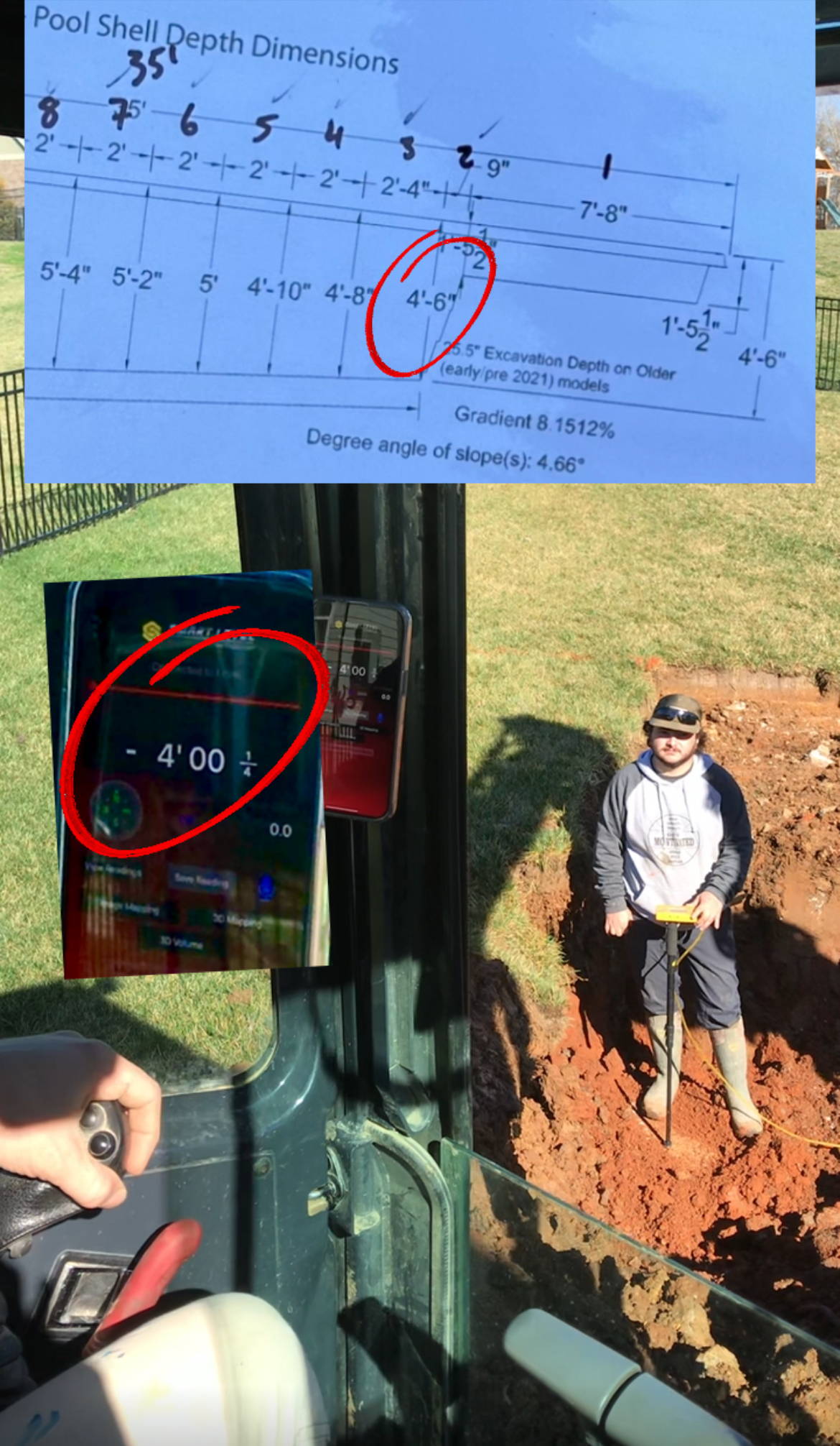
5)App inExcavator! Simply connect your Bluetooth-enabled device to the Smart Level,then position the device inside the excavator. Both the operator inside theexcavator and the crew in the dig site can view the precise digital readoutsimultaneously, ensuring faster, more efficient, and highly accurate measurements.With no need for extra attachments or software, this feature is a seamless andconvenient bonus - and free!
6)Smart Level'stubing is designed to withstand the toughest conditions. Smart Level'spolyurethane tubing is built to endure harsh conditions, including weight fromskid steers and extreme temperatures. We've showcased its strength in videoswhere it’s driven over by loaded skid steers, forklifts, and utility trucks.Unlike competing tubing, which can be vulnerable to high temperatures and pressure,Smart Level’s tubing is an ideal choice for construction/ job sites due to itsdurability and reliability.
While it'sincredibly durable, it's not indestructible. If the tubing is accidentally cutby rebar or other hazards, you can easily remove the damaged section andreattach it to the Smart Level readout. Repairs are quick and straightforward,typically taking just 5–15 minutes. Step-by-step videos are available to guideyou through the process!
7)Our ImageMapping and AR Mapping tools streamline, accelerate, and improve job biddingand surveys. These mapping features enable you to create accurate andprofessional designs with ease.
Image Mappinginvolves overlaying height and distance data directly onto an image, removingthe need for manual sketches and drawings. While we recommend using a Drone(preferably DJI), any image source can be used, such as Google Earth, GoogleMaps, or satellite imagery. Our YouTube channel provides tutorials to guide youthrough the Image Mapping process.
AR Mapping simplifiesjobsite plotting and surveying by utilizing iOS’s augmented reality features,combined with Smart Level's height measurement capabilities—similar to the iOSaugmented reality measuring tape function.